Google 发布 WeatherNext 3:引入实时卫星数据,精度提升五倍
Google 推出旗舰 AI 气象模型 WeatherNext 3,通过整合实时卫星数据替代传统物理模拟,实现比前代高五倍的分辨率和每小时刷新能力。该模型已全面接入 Search、Gemini、Maps 及 Google Cloud,显著提升了降水预测与清洁能源变量的准确性。
报道正文
本文目录5 个章节
我们旗舰级的 AI 天气预报模型现已纳入实时卫星数据、每小时刷新、更高分辨率、精准降水预报以及清洁能源变量。该模型已全面集成至搜索(Search)、Gemini、地图(Maps)、Google Maps Platform 和 Cloud 中。
WeatherNext 团队
您的浏览器不支持音频元素。
收听文章 [[duration]] 分钟
Google 推出了 WeatherNext 3,这是一款先进的 AI 模型,通过利用实时卫星数据而非传统物理模拟,提供更准确的高分辨率天气预报。此次更新提供每小时、本地化的预测,清晰度比之前版本提高五倍,为农业、可再生能源和日常规划带来显著改进。您现在可以直接通过 Google 搜索、地图和 Gemini 访问这些增强型预报,或通过 Google Cloud 将数据集成到您自己的项目中。
摘要由 Google AI 生成。生成式 AI 处于实验阶段。
- 查看“介绍 WeatherNext 3”,这是我们迄今最先进、最准确的全球天气 AI 模型。
- 我们现在提供每小时、高分辨率的预报,清晰度比以前提高五倍。
- 我们的模型使用实时卫星数据,以惊人的精度追踪快速变化的天气。
- 您将获得更好的降雨和降雪预测,帮助您自信地规划一天。
- 这些更新正在逐步推出到 Google 应用中,帮助每个人做出更好的决策。
摘要由 Google AI 生成。生成式 AI 处于实验阶段。
Google 刚刚发布了 WeatherNext 3,一款使天气预报更快、更准确的 AI 模型。它利用实时卫星数据进行每小时更新,为您提供更清晰的室外状况概览。这有助于人们更好地应对暴风雨或晴天等情况进行规划。目前,它已为 Google 搜索和地图中的天气信息提供支持。
摘要由 Google AI 生成。生成式 AI 处于实验阶段。
探索其他风格:
Every day, the weather influences billions of decisions. Some are as simple as grabbing an umbrella before heading out the door, but others are far more consequential. Wind, rain, and extreme weather events, like heatwaves and droughts, have cascading impacts across agriculture, global supply chains, clean energy production, and national economies.
In recent years, AI has revolutionized weather forecasting, using historical records to make faster and more accurate predictions than traditional methods. Yet predicting highly local and rapidly changing weather has remained a challenge. Previous models often lacked sufficient spatial resolution, and struggled to incorporate real-time weather data from sources like satellites.
Today, Google DeepMind and Google Research are introducing WeatherNext 3, the most advanced and accurate global weather model to date, according to independent live evaluations by Brightband. Our model learns directly from real-time observations, enabling it to provide timely and more localized predictions for the weather events that impact people the most. By using raw satellite data to produce a forecast every hour in high resolution, our model makes reliable forecasts accessible across Google products worldwide.
Rapid weather prediction at unprecedented resolution
A forecast's utility often comes down to detail and how finely it resolves both time and space. WeatherNext 3 generates hourly forecasts at multiple spatial resolutions, maintaining physical consistency from broad global wind patterns all the way down to local topography.
With WeatherNext 3, we can visualize key surface variables — like temperature and moisture — at a 5-kilometer resolution, other surface variables at 10 kilometers, and atmospheric variables, like wind speed, at 25 kilometers. Overall, this provides a global weather picture roughly five times sharper than our previous model, WeatherNext 2, which produced forecasts on a 25-kilometer grid in 6-hour increments.
Figure 1: The end-to-end WeatherNext 3 system architecture. The model ingests live 1-hour geostationary satellite mosaics alongside traditional historical analysis to feed a single, flexible Functional Generative Network (FGN) mesh transformer. It outputs dense gridded fields, discrete cyclone tracks, and predicts station-level sparse coordinates natively.
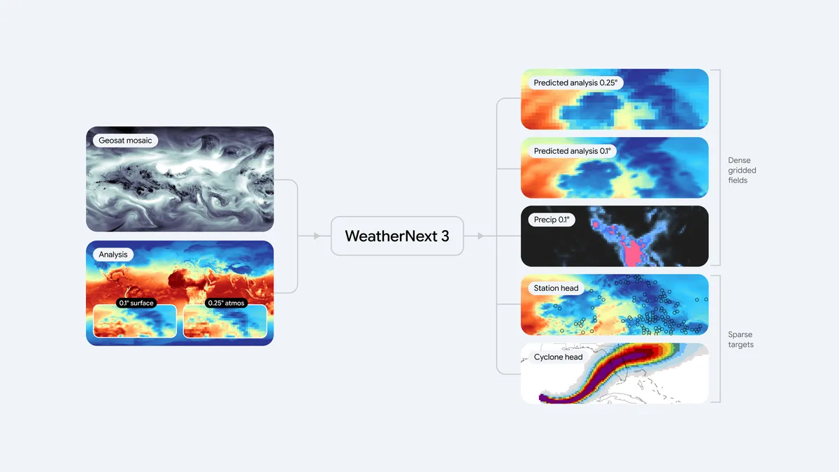
Figure 2: Comparison of 2-meter temperature forecasts over the UK. WeatherNext 2 (left) at 25-kilometer (0.25°) resolution vs. WeatherNext 3 (right) at a native 5-kilometer (0.05°) resolution. WeatherNext 3 resolves the intricate local topography, preventing the pixelated, over-smoothed thermal representations seen in older models.
Real-world data at continuous global scale
WeatherNext 3's biggest leap forward is what it learns from. Most AI weather models, including WeatherNext 2, are trained on data from numerical weather prediction (NWP) models. Although useful, NWP models are complex, supercomputer-driven physics simulations that carry a six-hour data lag. This lag can lead to biases for fast-changing variables like rain or surface temperature.
By ingesting a mosaic of live, global geostationary satellite data, our new model gains a rich, continuously updating view of the atmosphere. This allows the model to generate a new forecast every hour, each one grounded in the most recent satellite observations available, at up to 5-kilometer resolution.
This is important because critical weather develops fast. When storms, fronts, or precipitation systems materialize suddenly, our rapid update cycle and higher resolution provides earlier, more detailed insights needed to help drive an effective response.
Some variables, like temperature and humidity, can fluctuate dramatically over just a few kilometers, which is particularly relevant for communities near coastlines, valleys, or mountain ranges. Traditional models struggle here because they train on representations of the atmosphere that lack detail and miss extreme local variations.
To address this, WeatherNext 3 instead trains directly on sparse weather station observation data. This allows us to make global forecasts on a 5-kilometer grid that account for regional details like topography.
This breakthrough is particularly vital for regions across Latin America, Africa, and Asia-Pacific that have historically been underserved by high-resolution forecasting due to the immense supercomputing costs of traditional regional models. It brings localized, high-fidelity forecasting to billions of people and local businesses in these areas.
Beyond improved resolution and forecast frequency, our model introduces predictions specifically engineered for renewable energy production. The model forecasts 100-meter wind speeds (roughly at turbine-height) for precise wind-energy output, alongside high-resolution cloud cover and sun radiation levels to help solar farms estimate how much light they will receive on the ground.
This data is crucial for global clean energy planning, allowing grid operators and renewables developers to accurately predict how much power their clean energy assets will generate and match it with consumer demand.
Precipitation forecasting at breakthrough accuracy
Global weather models notoriously struggle to accurately predict precipitation. Rain and snow systems are driven by fast-moving cloud processes on tiny scales that are hard to model accurately using traditional physics-based simulations. Consequently, AI forecasts often produce blurry estimates or miss the boundaries of severe storms entirely.
To solve this, we train our model on two exceptionally high-quality sources of precipitation data: NASA’s satellite-based Integrated Multi-satellite Retrievals for GPM (IMERG) and our own global precipitation reanalysis based on satellite radar.
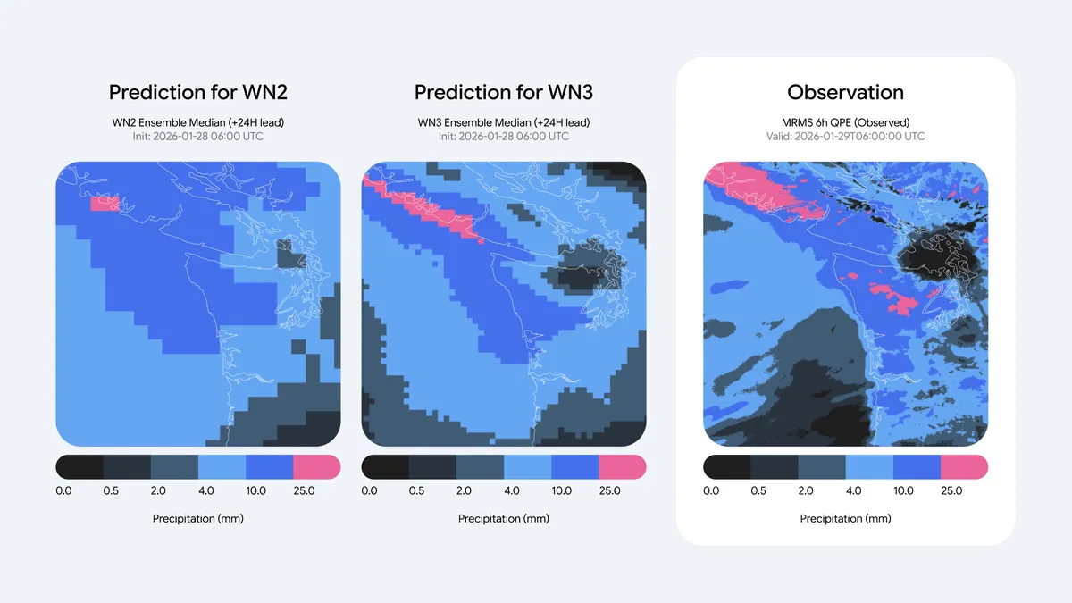
The result is a significant leap in precipitation forecasting accuracy. In medium-range global forecasts, evaluations against baselines show a Continuous Ranked Probability Score (CRPS) improvement of up to 60% against IMERG, 30% for MRMS, and 10% against rain gauge measurements for early lead times.
Figure 3: Medium-range probability of precipitation (PoP > 1mm) forecast comparison. WeatherNext 2 (left) at 25-kilometer resolution shows a highly diffused and pixelated precipitation footprint. WeatherNext 3 (middle) at 11-kilometer resolution closely mirrors the actual satellite ground truth (right), accurately capturing the sharp, convective bands of the weather systems.
Research applied across the ecosystem
Our primary goal is to advance weather intelligence to make it universally useful — whether for an emergency responder tracking sudden wind shifts, an air traffic controller planning flight paths, or a farmer managing crops.
[注:本文篇幅超长,以上为核心前篇精译,后续内容保留原文呈现]
To bring these breakthroughs out of the lab and into the real world, we’re integrating WeatherNext 3 across Google’s core ecosystem and beyond:
- High-resolution forecast data: We’re making global weather predictions, updated hourly and ready to integrate into your workflows with no model setup required. This enables researchers, developers and businesses to query the data in BigQuery and Earth Engine, or bulk-download from Google Cloud Storage.
- Available globally: WeatherNext 3 will begin powering weather experiences within Google Search, Gemini app, Google Maps, Google Maps Platform Weather API, and Google Earth Engine starting today. The update dramatically improves longer term forecasts. When planning a day or more ahead, people will see up to 50% more accurate precipitation forecasts — with the greatest improvements in regions where forecasts have historically been less reliable. So if you’re packing for a weekend trip or deciding the best day for an outdoor activity, you’ll now get more accurate predictions to help you plan.
The atmosphere will always retain a degree of unpredictability. However, by training on real-world observations and bypassing traditional modeling constraints, WeatherNext 3 brings us closer to a future where forecasts truly match what is happening on the ground.
To learn more about geospatial platforms and AI work at Google, check out Google Earth Engine, AlphaEarth Foundations, and Earth AI.
Disclaimer: For official weather forecasts, severe weather warnings, and public safety advisories, please refer to your local meteorological agency or national weather service.